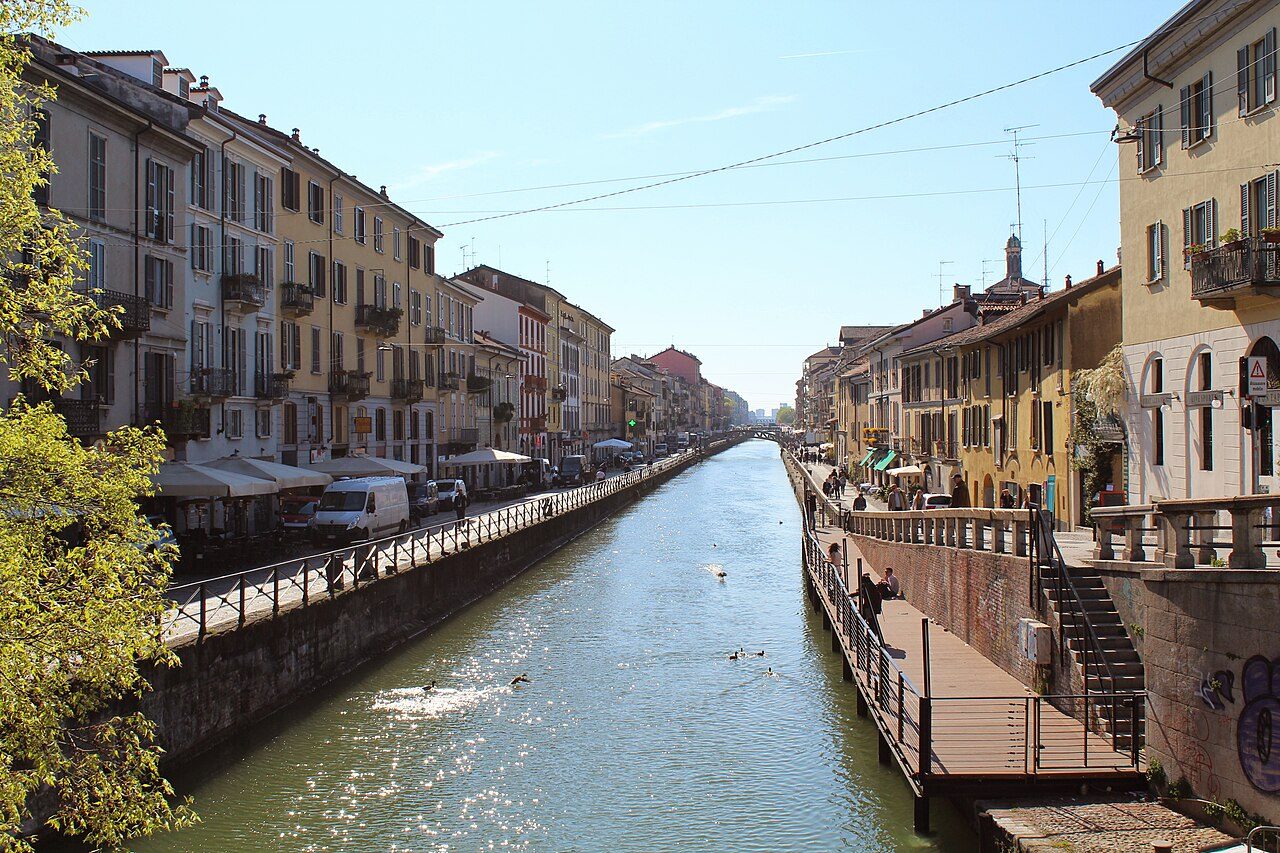
Monument · Ticinese and Navigli · 1156–1819
Navigli e Darsena
The port of a city with no sea, and the canals that ended up under the asphalt
In brief
Milan has no sea and no great river, so for centuries it dug its own water. What's left is the Darsena, the old port that became open water again in 2015, and two canals that once carried the marble for the Duomo. An open-air walk, one to read more than to look at.
Stories of this place
- Anecdote · Piazza XXIV Maggio and the Customs GateReadThe Oak That Is a MonumentIn Piazza XXIV Maggio in Milan, a few steps from the Porta Ticinese city gate, stands a big red oak that is a war memorial. The engineer Giunio Capè had it planted here in 1924, to celebrate his son's return alive from the First World War and to remember those who had not come back. The day chosen was May 24, the date Italy entered the war in 1915, which gives the square its name. At its foot a wrought-iron marker carries a dedication to the fallen of the neighborhood. Today the tree is old and ailing. When there was talk of cutting it down, the neighborhood objected.
- Record · The DarsenaReadThe Darsena, a Port Busier Than BariThe Darsena, the old port dug inside Milan, once had more traffic than some seaports. It sounds like a joke, but it's statistics. In 1936 about seventy barges a day came in: enough, according to the most often quoted figures, to beat the ports of Bari, Brindisi and Messina. In 1953 the Darsena still ranked thirteenth among Italian ports for goods received and third for tonnage. The figure was inflated by a single cargo, sand, needed to rebuild the city after the war. Cranes unloaded it in great heaps on the bank, and the sabbioni, the big sands, became one of Milan's typical landscapes.
- Anecdote · The DarsenaReadThe Seaport That Stayed on PaperBy the early 1900s the Darsena, Milan's old port, was no longer enough: too many barges. In 1907 a new port was proposed southeast of the city, linked to the Po river by a canal running as far as Cremona. The plan was approved ten years later, and in 1919 the digging began. Then groundwater filled the excavation, the work stopped and fishermen moved in on the pond. The port was never born. The name stayed: that part of Milan, far from any sea, is still called Porto di Mare, the seaport.
- Anecdote · The DarsenaReadThe Last Barge into Milan's PortThe story of freight on the Navigli, Milan's canals, has a precise ending. At the end of March 1979, in the early afternoon, the last barge came into the Darsena, the city's old port. It was nearly forty meters long, it came from Castelletto di Cuggiono, a village along the Naviglio Grande, and it carried a hundred and twenty tons of sand. With that load, the carrying of goods on Milan's canals came to a close. After nearly four centuries the port of Milan had stopped working.
- Anecdote · The Scodellino and the TrofeoReadThe Monument That Beat the CanalThe Naviglio Pavese, the canal to Pavia, starts from the Darsena, Milan's old port. In the early 1600s the Count of Fuentes, the city's Spanish governor, had a trophy put up to celebrate it. Too bad only the start of the canal existed. After Fuentes died the work was suspended, and a lock left in the middle of nowhere earned the name Conca Fallata, the failed lock. The Naviglio Pavese was finished only in 1819. The trophy was later removed, but the bridge where the canal leaves the Darsena is still called the Ponte del Trofeo, the trophy bridge.
- Anecdote · The Naviglio Grande and the Duomo's MarbleReadThe Podestà Killed over Canal TaxesThe Naviglio Grande, the canal that brings the water of the Ticino river to Milan, cost a podestà his life. A podestà was the outside magistrate called in to govern the city, and in 1257 the post belonged to Beno de' Gozzadini, from Bologna. Under him the digging of the canal moved forward toward Milan. Paying for it took taxes, and Gozzadini insisted that churches and monasteries pay them too. The clergy stirred up the people against him. At the end of his term Gozzadini was tried and convicted, then brutally killed, and his body ended up in the city moat. The boats arrived more than ten years later.
- Anecdote · The Naviglio Grande and the Duomo's MarbleReadLeonardo's WaterOn the Naviglio Grande, the canal that carries Ticino river water to the Darsena, Milan's old port, Leonardo da Vinci, artist and engineer, owned something unusual: water. Louis XII, the king of France who ruled Milan in the early 1500s, had given him a water right at San Cristoforo, along the canal. It meant he could draw water from the Naviglio, precious in a countryside that lived on irrigation. Leonardo did not forget it. In his will, dictated in France a few days before he died, he left that right to his servant, Battista de Vilanis. To the very end, a little of the Naviglio's water was his.
- In culture · The Naviglio Grande and the Duomo's MarbleReadAlda Merini's Bridge on the NaviglioAlda Merini, one of the best-loved voices of twentieth-century Italian poetry, lived in Milan, a short walk from the Naviglio Grande, the oldest of the city's canals. In November 2019, ten years after her death, Milan named a bridge over the canal after her, at the corner of the Ripa di Porta Ticinese and Via Corsico. The choice was no accident: it was close to her home, and it was singled out as a place that stood for her life and her poetry.
- In culture · The Vicolo dei LavandaiReadSimenon in the Washermen's AlleyIn the late 1950s Georges Simenon, the Belgian writer who invented Inspector Maigret, visited Milan looking for ideas. The photographer Emilio Ronchini portrayed him in the Vicolo dei Lavandai, the washermen's alley, home to an old public washhouse just off the Naviglio Grande canal. The feature ran in the weekly magazine Epoca at the end of December 1957.
Ready-made questions
Because it has no sea and no great river, and a city without water can't defend itself and can't trade. The first dig, in 1156, was a moat around the walls. Then came the real canals, which took their water from the Ticino and Adda rivers. They did three jobs at once: moving heavy goods like marble and sand, irrigating the countryside and protecting the city. The Grande alone fed more than a hundred irrigation outlets.
No, though you'll often hear it said. When Leonardo da Vinci arrived in Milan, the Grande had existed for nearly three centuries and the first for a few decades. Leonardo studied the canals and drew lock gates in the Codex Atlanticus, the kind still called vinciane, after him, today. But he didn't invent them, and a curator at Milan's Museo della Scienza, the science museum, admits that nobody quite knows what his contribution was. He may have advised Duke Ludovico il Moro on the locks that linked the Martesana canal to the Cerchia.
Go to stop: The Canals You Can't SeeUnder the streets. Around the center ran the Cerchia dei , a navigable ring of water. Between 1929 and 1930 it was covered over: the water barely circulated, it was polluted, it raised health worries and it took space away from traffic. Today its course is a ring of streets, made up of roads like Via Senato, Via Visconti di Modrone, Via Francesco Sforza and Via Carducci. In this area the Naviglio Grande, the Naviglio Pavese and the are still open to the sky, which is exactly what you see on this walk.
Go to stop: The Canals You Can't SeeIt comes from the Ticino river. The Grande draws it off at Tornavento, some fifty kilometers from here, and carries it to the , dropping about thirty meters in all. It leaves the Darsena by the Naviglio Pavese, which in just over thirty kilometers returns it to the Ticino, at Pavia. There the drop is more than fifty meters, and the canal handles it with twelve . A small outflow canal, the Cavo Ticinello, carries off the excess water.
Go to stop: The Scodellino and the TrofeoIt is how a boat climbs or descends a step of water. Picture a chamber closed by two gates, one upstream and one downstream. The boat goes in, the gate shuts behind it, the water is raised or lowered to the level of the next stretch, then the other gate opens. In Italian it is called a . Milan's first was the Conca di Viarenna, of 1438: it overcame the difference of about two meters between the and the Cerchia dei .
Go to stop: The Canals You Can't SeeNo. On the Pavese the last cargo barges passed in the 1960s, and on the Naviglio Grande the last one reached the in 1979. Since then the water in the canals has mostly gone to irrigating fields. The boats you may see today carry people, not goods. With the works of 2015 the Darsena became open water again: the old port looks like a port once more.
Go to stop: The DarsenaBecause the washing was done by men. Milan had a Confraternita dei Lavandai, a washermen's confraternity, from the 1700s, with a patron saint, Sant'Antonio da Padova, and an altar in the nearby church of Santa Maria delle Grazie al . They worked on their knees at the water's edge, rinsing the laundry in the little channel and scrubbing it on stone. By the time of the Second World War it was women who did the washing. The in the alley stayed in use until the 1950s.
Go to stop: The Vicolo dei LavandaiThe stops
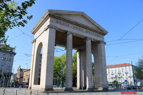
1 Piazza XXIV Maggio and the Customs Gate
This gate was built to celebrate one of Napoleon's victories and to make anyone entering the city pay duty. Around it was a livestock market and, a short walk away, the port. This is where the Milan of dry land ended and the Milan of water began.
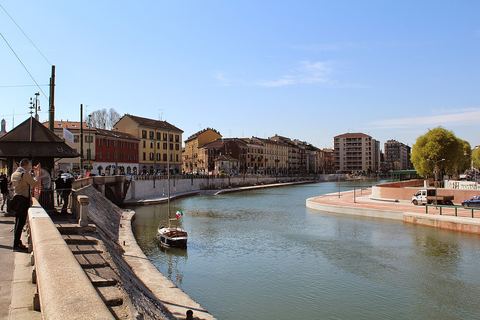
2 The Darsena
A port dug inside the city in 1603 by the Spanish governor. For nearly four centuries it took in barges, in the end loaded mostly with sand. The last one came in in 1979. Since 2015 the basin has been open water again.
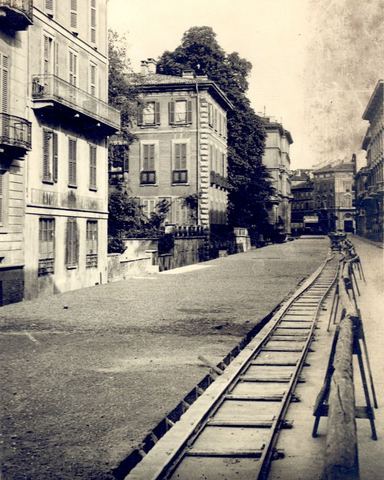
3 The Canals You Can't See
The Darsena is what's left of a much larger network. Around the center ran the Cerchia dei Navigli, a ring of water that began as a defensive moat. It was covered over between 1929 and 1930 and today it is a ring of streets.
4 The Scodellino and the Trofeo
Two bridges, two canals, two curious names. The Scodellino, tradition says, recalls the boatmen's soup. The Trofeo recalls a monument put up in the early 1600s to celebrate a canal that would be finished more than two centuries later.
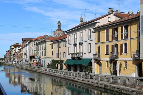
5 The Naviglio Grande and the Duomo's Marble
The oldest of the Navigli has been bringing the water of the Ticino river to Milan for eight hundred years. Down this canal came, block after block, the marble for the Duomo, on boats that paid no duty.
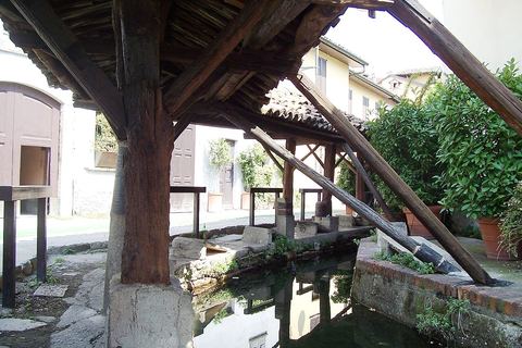
6 The Vicolo dei Lavandai
A public washhouse that has survived almost intact, in use from the 1800s to the 1950s. At first the washing was done not by women but by men, gathered in a confraternity. Here the Navigli stop being engineering and become everyday life.
Timeline
- 1156Milan digs a defensive moat around its walls. In time it will become the Cerchia dei Navigli.
- 1211The Naviglio Grande, with water from the Ticino, reaches the city's edge near Sant'Eustorgio. A few decades later it becomes navigable.
- 1438Filippo Maria Visconti has the Conca di Viarenna built, the first lock on Milan's Navigli, to bring marble closer to the Duomo site.
- 1603The Count of Fuentes, the Spanish governor, turns the pond of Sant'Eustorgio into a port set against the walls: the Darsena.
- 1819The Naviglio Pavese opens, decided by Napoleon and finished under the Austrians, over two centuries after the first Spanish attempt.
- 1929–1930The Cerchia dei Navigli is covered over and becomes a ring of streets. The canal that linked it to the Darsena disappears too.
- 1979The last barge, loaded with sand, comes into the Darsena. Freight transport on Milan's Navigli is over.
- 2015After a year and a half of work the Darsena reopens as open water, on the eve of Expo.
Who's who
Pedro Enríquez de Acevedo, Count of Fuentes
Spanish governor of Milan
In 1603 he turned a pond into the city's port. In the same years he had a trophy put up for a canal to Pavia that he never managed to finish.
Gian Galeazzo Visconti
lord of Milan
In the late 1300s he granted the Fabbrica del Duomo the marble of Candoglia and exemption from duties. From then on the blocks traveled down the Naviglio Grande.
Beno de' Gozzadini
podestà, chief magistrate, of Milan in the 1200s
He ordered the works to widen the Naviglio Grande and lower its bed, which made it navigable. He got no thanks for it: he ended up lynched by the citizens.
Ludovico il Moro
duke of Milan
In the late 1400s he linked the Naviglio della Martesana to the Cerchia, joining the waters of the Adda and the Ticino. His coat of arms is on the plaque at the Conca di Viarenna.
Leonardo da Vinci
artist and engineer at the Sforza court
He studied Milan's canals and drew their locks in the Codex Atlanticus. He didn't design them: when he arrived in the city the Navigli had existed for centuries.
Napoleon Bonaparte
emperor of the French and king of Italy
In 1805 he decreed that the canal from Milan to Pavia be made navigable. The gate in Piazza XXIV Maggio, originally Porta Marengo, was built to celebrate one of his victories.
Words to know
Where it is
The neighborhood
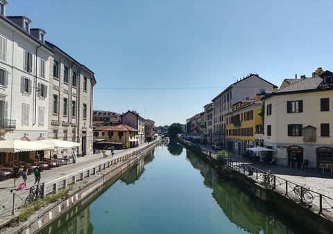
Ticinese and Navigli
Related places
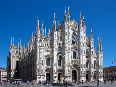
The story of the place
Milan has no sea and no great river. For centuries it solved the problem its own way: it dug its water. A network of canals, the , linked the city to the Ticino and Adda rivers, and through them to the lakes, the Po and the sea.
From moat to canal network
It all starts as defense. In 1156 the city rings itself with a water-filled moat. A few years later the emperor Frederick Barbarossa destroys Milan and the moat with it, but the Milanese dig it out again. Over time that moat becomes the Cerchia dei , the ring of canals, a navigable loop around the center.
Meanwhile the Grande, the great canal, arrives from the west, bringing the water of the Ticino into the city and, from the 1200s, boats as well. This is the route the marble for the Duomo, Milan's cathedral, travels from the late 1300s.
The Visconti and the Sforza, the ruling families of Milan, add , new canals and a link to the Adda. In 1603 the Count of Fuentes, the Spanish governor, turns an old pond at the foot of the city walls into a real port: the , the dock. Two centuries later comes the Pavese, the canal to Pavia, ordered by Napoleon and finished by the Austrians.
Water covered and recovered
Then the city changes its mind about water. Between 1929 and 1930 the Cerchia is covered over and becomes a road. The port holds on for a few more decades, mostly thanks to sand for building sites, until the last barge comes in in 1979. The is neglected for years, comes close to ending up on top of an underground garage, and in 2015 becomes open water again.
How to read the walk
There is no monument to admire here. There is a system to understand. You have to picture what's missing: the barges, the horses that pulled them from the bank, the customs guards, the canals buried under the streets of the center.
The route has six stops, all outdoors: a gate, the port, the vanished ring, two bridges with curious names, the marble road and an alley where the laundry was done. If you're short on time, keep the , the Grande and the alley.
Sources
- Naviglio, Enciclopedia Treccani on line (opens in a new tab)Encyclopedia
- Ufo, Vocabolario Treccani (opens in a new tab)Encyclopedia
- Darsena di Milano, in-Lombardia (Regione Lombardia) (opens in a new tab)Institution
- The Worksites of Milan Duomo, Veneranda Fabbrica del Duomo di Milano su Google Arts & Culture (opens in a new tab)Institution
- Darsena, Italy for Movies (Ministero della Cultura e Cinecittà) (opens in a new tab)Institution
- Leonardo e le porte vinciane, Il Post (opens in a new tab)Other source
- Milano intitola un ponte del Naviglio Grande ad Alda Merini, Sky TG24 (opens in a new tab)Other source
- Va in scena il salone nautico e i milanesi riscoprono la Darsena, Linkiesta (opens in a new tab)Other source
- Ponte dello Scodellino, OpenStreetMap (opens in a new tab)Other source
- Cronologia di Milano dal 1251 al 1275, Storia di Milano (opens in a new tab)Other source
- Gozzadini, Benno, Dizionario Biografico degli Italiani (Treccani) (opens in a new tab)Encyclopedia
- Leonardo's Will, in J. P. Richter, The Notebooks of Leonardo da Vinci, n. 1566 (opens in a new tab)Other source
- Leonardo's Will, in J. P. Richter, The Notebooks of Leonardo da Vinci, n. 1566, From Old Books (opens in a new tab)Other source
- Memorie storiche su la vita, gli studj e le opere di Lionardo da Vinci, Wikisource (opens in a new tab)Other source
- Monumento ai caduti della prima guerra mondiale in piazza XXIV Maggio, Catalogo generale dei beni culturali (opens in a new tab)Institution
- The Red Oak of Porta Ticinese, in-Lombardia (Regione Lombardia) (opens in a new tab)Institution
- La quercia storica e i formaggiai, Il Giorno (opens in a new tab)Other source
- La quercia in 24 Maggio ha gli anni contati, Il Giorno (opens in a new tab)Other source
- La quercia di Piazza XXIV maggio, Italian Botanical Heritage (opens in a new tab)Other source
- I guai di Porto di Mare, Il Giorno (opens in a new tab)Other source
- Il Porto di Mare di Milano: il porto fluviale mai realizzato, MilanoFree (opens in a new tab)Other source
- Cerchia dei Navigli, Wikipedia (opens in a new tab)Wikipedia
- Darsena di Milano, Wikipedia (opens in a new tab)Wikipedia
- Navigli (Milano), Wikipedia (opens in a new tab)Wikipedia
- Navigli, Wikipedia in inglese (opens in a new tab)Wikipedia
- Naviglio Grande, Wikipedia (opens in a new tab)Wikipedia
- Naviglio Pavese, Wikipedia (opens in a new tab)Wikipedia
- Conca di Viarenna, Wikipedia (opens in a new tab)Wikipedia
- Porta Ticinese, Wikipedia (opens in a new tab)Wikipedia
- Vicolo dei Lavandai, Wikipedia (opens in a new tab)Wikipedia
- Porto di Mare, Wikipedia (opens in a new tab)Wikipedia